


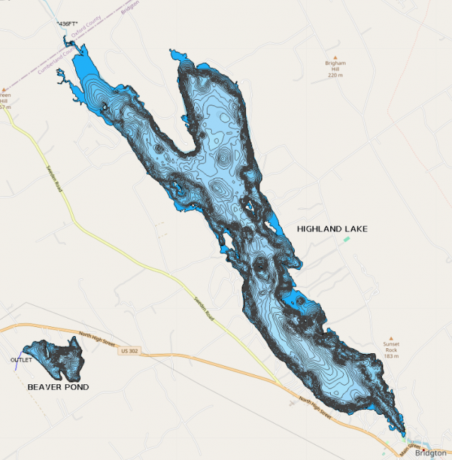
Highland Lake has a public boat launch, next to the town beach off of Highland Road.

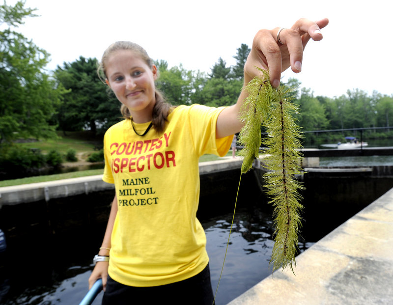
Originally called Crotched Pond, Highland Lake stretches from downtown Bridgton up to the edge of Sweden. It has over 16 miles of shore frontage, two coves and numerous islands, which provide a variety of scenery and habitat to explore. Swimming, angling, water-skiing, sailing, rowing, wildlife watching and general relaxing are all common on the lake in the summer. In the winter, cross-country skiers, ice- fishermen and snowmobilers all enjoy the lake. It is also the center for many activities during Bridgton’s Winter Carnival. Courtesy boat inspectors work at the public boat launch all summer, while water testing interns collect data used to monitor the lake health.
Highland Lake is best suited to warmwater fish as the small amount of cool water present in the summer months is low in dissolved oxygen. Brown trout, however, are more tolerant of warm water than other salmonids and is heavily stocked in the lake. Other species found in the lake include smallmouth bass, largemouth bass, white perch, yellow perch, chain pickerel, hornpout, Eel, white sucker, minnows.
A TMDL is a detailed watershed report with land use information and phosphorus loading estimates for a specific lake. The acronym TMDL stands for “Total Maximum Daily Load” and for Maine lakes it is used as a tool to assess and reduce phosphorus loading from within the entire watershed. Working with the Maine Association of Conservation Districts and Maine Department of Environmental Protection, LEA helped compile, organize and write a TMDL for Highland Lake. The non-regulatory reports are intended to serve as a platform for future implementation work and watershed planning. It can also be used to compliment comprehensive planning updates. In addition to the land use inventory and phosphorus loading estimates, the report contains water quality, fishery and soils information, a shoreline survey and recommendations for future best management practices in the watershed. The completed Highland Lake TMDL is available now and can be viewed online through the Maine DEP website at Highland Lake TMDL.
10 percent of soils in the watershed are type A soils. Type A soils tend to be well drained sands, loams, and gravels. When vegetation is removed and the soil is exposed they can be susceptible to erosion. Because they are often coarse with ample pore space, there is low runoff potential and water will not usually pool on them. These soils can be good places to site leach fields or infiltrate stormwater from a home or residence.
8 percent of soils in the watershed are type B soils. B soils have moderate infiltration rates and fine to moderate texture and soil size. They are usually made up silts and loams. Although not as well drained as A soils, they can also be good places to site leach fields and infiltrate stormwater.
59 percent of soils in the watershed are type C soils. C soils have low infiltration rates and typically have a layer that impedes the movement of water. These soils are made of sands, clays, and loams and are one of the most common soil types in western Maine.
1 percent of soils in the watershed are type D soils. D soils have a high runoff potential and very low infiltration rates. Soils with a high water table, clay or other impervious layer near the surface are typically D soils. These soils are often associated with wetlands.
1 percent of soils in the watershed are type C/D soils. C/D soils are a mix of these two soil types. They have fairly high runoff potential and low infiltration rates and often pool water.
The remaining 20 percent of the watershed is taken up by the lake.
The primary purpose of this project was to significantly reduce erosion and export of sediment and phosphorus into Highland Lake. This multi-year grant, which ended in 2008, installed conservation practices that reduced erosion and polluted runoff at close to 40 sites throughout the watershed. Roads, residential areas and public lands have all been addressed. Fixes included new vegetative buffer gardens, infiltration trenches, and road work designed to improve drainage and reduce wash-outs. Landowners who participated in the project received funding for up to 50 percent of the cost of the work done. The project also hosted a series of workshops to raise awareness about watershed problems and work to foster long-term watershed stewardship.

 CBI Program
 Open Water Quality Monitoring